Copy this text
CTD profiles in the western and central Mediterranean between 2007 and 2020 from Italian cruises
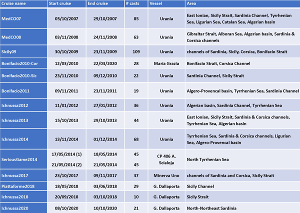
Fifteen oceanographic cruises were organized in the western and central Mediterranean basins between October 2007 and October 2020 (see the table) by the Italian National Research Council (CNR) and the acquisition of 661 hydrological vertical profiles. The cruise carried out in 2015 is part of another database (Ribotti et al., 2019a) while in 2016 no cruise was planned and in 2019 it was cancelled due to bad weather conditions. Data of conductivity (SBE-4 sensor, resolution of 3 x 10⁻⁴ S/m), temperature (SBE-3/F thermometer, resolution of 0.00015 °C/bit at -1 °C or 0.00018 °C/bit at 31 °C), dissolved oxygen (DO; SBE-43 polarographic membrane sensor with a range of 120% of surface saturation and an accuracy of ±2% of saturation), Chlorophyll-a fluorescence (Chl-a; Sea Tech Inc. fluorometer with energy emitted by the flash lamp of 0.25 J for flash, temperature range 0 ° - 25 °C, resolution 0.15 mg/l) reported as Relative Fluorescence Unit. A Chelsea Aqua 3 fluorometer has been used, while no fluorescence data were during the two cruises Bonifacio2010, -Sic and -Cor. Turbidity was acquired just during Bonifacio2011 by a Seapoint, and by a WET Labs ECO-NTU during Piattaforme2018 and Ichnussa2020. The pH/Redox sensor (SBE27) was available just during the cruise Piattaforme2018 but calibrated one year before. Pre-cruise and post-cruise calibrations of first and redundant sensors of temperature, salinity and dissolved oxygen were performed by CNR technicians at the NATO-CMRE Center in La Spezia (Italy). After acquisition data were quality checked and processed by the Sea-Bird Seasoft software, and the coarse errors corrected. On board the R/V Urania and R/V Minerva Uno, salinity was checked against the onboard analyses of water, sampled at pre-defined depths, by a Guildline-Autosal salinometer, while on the other vessels all samples were analyzed once back at CNR. The same for dissolved oxygen, checked against Winkler titration analyses onboard. This post-cruise calibration was not done on data acquired during the cruise Piattaforme2018.Chl-a, pH and turbidity, where available, data were not calibrated. These procedures of quality assurance and check are widely described in Ribotti et al. (2020). Furthermore, in the framework of the MEDESS4MS project (see info on https://keep.eu/), on 17 and 21 May 2014 two daily cruises, SeriousGame2014-1 and -2, were jointly held by the CNR is Oristano with the CNR in Ancona and the Italian Coast Guard. The two surveys covered, with 45 casts each, about 880 km2 of shelf on a 5 x 5 km spatial grid in latitude and longitude of an area located north of the Elba island in the Tuscany Archipelago, northern Tyrrhenian Sea. The CTD probe was a Seabird SBE19 plus V2 equipped with sensors of pressure, temperature, conductivity, SBE 63 for dissolved oxygen, WET-Lab FLNTU for turbidity (NTU) and Chlorophyll (ug/l) and, just during the second cruise, a Turner Cyclops sensor for the Chromophoric Dissolved Organic Matter (CDOM in ppb QS - Quinine Sulfate). The probe was calibrated on January 29th 2013 but not before and after the two cruises, for what is known, so data were just quality checked and processed by the Sea-Bird Seasoft software, and the coarse errors corrected. This database is integrated with other two covering the period 2000-2006 for western to eastern Mediterranean (Ribotti et al., 2019b, Ribotti et al., 2019c). The data set is provided per cruise as Ocean Data View (ODV, Schlitzer, 2022. Ocean Data View. https://odv.awi.de) Spreadsheet files in TXT format where missing data values are set to -1.e10.
List of cruises organized in the period 2007-2020 with number of casts, research vessels used and areas interested (with at least two casts)

Disciplines
Physical oceanography, Biological oceanography, Chemical oceanography
Keywords
Hydrological data, water masses, Mediterranean Sea, CTD profiles
Location
45N, 34S, -7E, 17W
Devices
Cruise name
Station
Type of acquisition (here C)
Date in mon/day/yr and Time in hh:mm
Longitude [degrees_east]
Latitude [degrees_north]
Bot. Depth [m]
Data
| File | Size | Format | Processing | Access | |
|---|---|---|---|---|---|
Cruise MedCO07 in compressed ODV Spreadsheet TXT format and map | 3 Mo | TEXT | Quality controlled data | ||
Cruise MedCO08 in compressed ODV Spreadsheet TXT format and map | 2 Mo | TEXT | Quality controlled data | ||
Cruise Sicily09 in compressed ODV Spreadsheet TXT format and map | 1 Mo | TEXT | Quality controlled data | ||
Cruise Bonifacio2010-Cor in compressed ODV Spreadsheet TXT format and map | 301 Ko | TEXT | Quality controlled data | ||
cruise Bonifacio2010-Sic in compressed ODV Spreadsheet TXT format and map | 552 Ko | TEXT | Quality controlled data | ||
cruise Bonifacio2011 in compressed ODV Spreadsheet TXT format and map | 1 Mo | TEXT | Quality controlled data | ||
cruise Ichnussa2012 in compressed ODV Spreadsheet TXT format and map | 1 Mo | TEXT | Quality controlled data | ||
cruise Ichnussa2013 in compressed ODV Spreadsheet TXT format and map | 1 Mo | TEXT | Quality controlled data | ||
cruise Ichnussa2014 in compressed ODV Spreadsheet TXT format and map | 2 Mo | TEXT | Quality controlled data | ||
cruise Ichnussa2017 in compressed ODV Spreadsheet TXT format and map | 807 Ko | TEXT | Quality controlled data | ||
cruise Ichnussa2018 in compressed ODV Spreadsheet TXT format and map | 327 Ko | TEXT | Quality controlled data | ||
cruise Ichnussa2020 in compressed ODV Spreadsheet TXT format and map | 331 Ko | TEXT | Quality controlled data | ||
cruise Piattaforme2018 in compressed ODV Spreadsheet TXT format and map | 626 Ko | TEXT | Quality controlled data | ||
cruises SeriousGame1-2_2014 in compressed ODV Spreadsheet TXT format and map | 445 Ko | TEXT | Quality controlled data |

