1450 result(s)
123...145
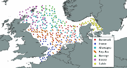
IBTS surveys (International Bottom Trawl Survey) are carried out within an international framework. Main countries bordering the North Sea participate to it according to the European Community regulations (EC N°1543/2000 and N° 1639/2001) which specify that countries from E.U. have to carry out surveys at sea in order to evaluate abundance and stocks distribution, independently of commercial fisheries data. The first target of the IBTS survey is [...]
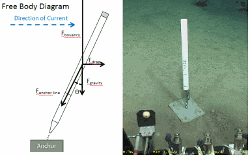
This dataset contains current data acquired between june 2022 and July 2023 using 5 TCM-3 Ocean Bottom Tilt Current Meters installed next to the Tour Eiffel, hydrothermal vent site and near the SeaMon west station. The TCM-3 Ocean Bottom Tilt Current Meter from Lowell Instruments LLC (North Falmouth, MA, USA) measures current using the drag-tilt principle. The logger is buoyant and is anchored to the bottom via a short flexible tether. Drag from [...]
The SOMLIT-Like -Lanvéoc time series data characterize the hydrology of the Bay of Brest, at 48°17'39"N - 04°27'09"W location. The Bay of Brest is a semi-enclosed, macro-tidal, marine ecosystem of 180 km2, connected to the Iroise Sea by a narrow and deep strait of 2 km width, and 40 m depth max. It is under the influence of the Aulne river, representing 70% of the total river discharge. Fortnightly measurements have been undertaken since January [...]
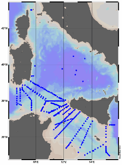
This data set contains the CTD data collected by the Stazione Oceanografica of CNR (Italy) from RV URANIA during eight oceanographic campaigns (Table 1). These cruises were part of an intensive field program in the Sicily Channel and in the southern Tyrrhenian basin conducted within the MATER project, funded under FP4-MAS3 (Grant agreement ID: MAS3960051). Data have been used in several studies (see Related documents). Table1 Cruise name [...]
SWINGS (https://swings.geotraces.org/en/homepage-english/) is a multidisciplinary 4-year project fully dedicated to elucidate trace element sources, transformations and sinks along a section crossing key areas of the Southern Ocean (SO). SWINGS aims at 1) establishing the relative importance of sedimentary, atmospheric and hydrothermal sources of trace elements and isotopes (TEIs) in the Indian sector of the SO, 2) investigating the drivers of th [...]
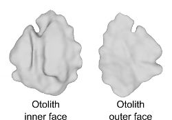
This dataset includes 3D sagittal left otolith meshes obtained from 339 individual red mullet (Mullus barbatus) specimens. These samples were collected from 17 distinct geographical locations spanning the whole Mediterranean Sea. Recorded biological parameters include fish total length (TL, ranging from 125 to 238 mm), total weight (W, ranging from 14.9 to 168.0 g), sex, and sexual maturity staging. The 3D otolith dataset consists of high-resolut [...]
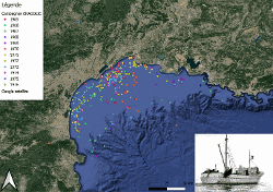
This dataset contains an inventory of bentho-demersal fauna captured by bottom trawling in Corsica and in the north of Sardinia. There are also counts, measurements of weight, length and sexe determination of individuals. This exploratory bottom trawl survey aimed at evaluating the fishing possibilities in the region. Unfortunatly the exact location of each station could not be recovered. According to the institute 1964 activity report, this su [...]
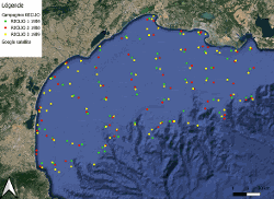
Three Reclio surveys took place between june 1988 and february 1989, two surveys in 1988 and one in 1989. The objective of all this serie of survey was to study the seasonal macrodistribution and the importance of age groups 0 and 1 of the main commercial species fished by bottom trawl in the Gulf of Lion. About sixty trawl hauls were carried out during each survey, with 30 minutes mean duration of each haul. An inventory of the main bentho-demer [...]
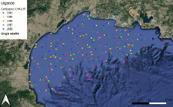
This dataset includes all the CHALIST surveys between 1983 and 1992, that is five surveys undertaken in 1983, 1985, 1986, 1987 and 1992. The aim of CHALIST surveys was to evalute the demersal resources of the Gulf of Lion in order to monitor annual variations of the main commercial species in terme of spatial distribution, average weight and size and age compositions and abundance indices. All the target species collected were identified, weighte [...]
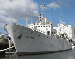
This dataset illustrates a study of the trawlable seabed of the Gulf of Lion, which took place over 11 years between 1965 and 1976. An inventory of the bentho-demersal community was carried out by bottom trawling. Measurements of total weight were taken as well as sex determination. This study was carried out with the research vessel Ichthys.